Super Typhoon Yagi is disrupting shipping around east Asia, south east Asia, trade media are reporting. The violent weather system is bearing down on the Chinese coast at the island of Hainan, a short distance from the metropolitan areas of Guangzhou, Shenzhen, and Hong Kong.
The system will create at least some temporary disruption because of its proximity to major international sea ports (see below) in East Asia; Australia’s trade will likely be at least a little disrupted as about 40.6% of all our containerised cargo originates from East Asia. About 30 per cent of our containerised export cargo is destined for East Asia and about 46 per cent of our containerised import cargo originates in East Asia.
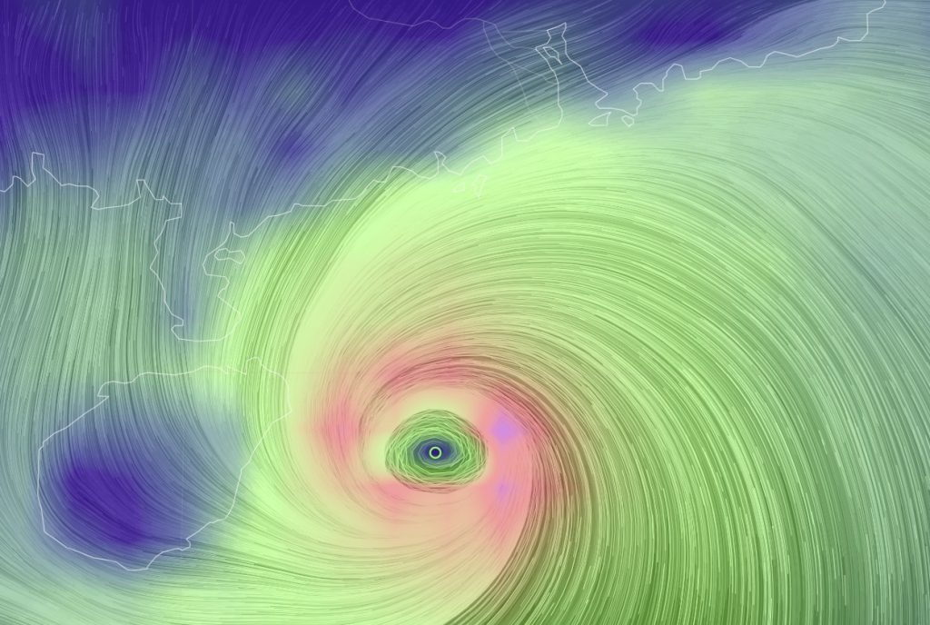
As at the time of researching this article, the eye of the storm is at 19.31 degrees north and 112.38 degrees east, approximately 305 km (265 nautical miles) south-west-by-south from Hong Kong as at 10:38 AEST on 06 September 2024, according to Earth NullSchool, which draws upon data provided by the US National Aeronautics and Space Administration. The winds marked with the purple-ish splotches (see graphic at the top of this post) are moving at approximately 158-160km / hour whereas the winds in the light yellow-green (upper left) are moving at about 85 km / hour. Significant wave heights in to the upper right of the eye are reaching about 12 metres.
The eye is to the east of the Chinese island of Hainan, while Hong Kong, Guangzhou and the Shenzhen metropolitan areas, which are be found just right of upper centre of the featured image on the Pearl River Estuary, are to the north-north-east of the system. The Pearl River estuary region contains several major container terminal ports. Ningbo-Zhoushan is the top three container throughput port in the world, according to international maritime publication Lloyd’s List, with about 33.3m TEU in 2022. Shenzhen, also in China, is close behind at approximately 30m TEU; Guangzhou is sixth on the list at just under 25m TEU, and Hong Kong is ninth with just over 16.6m TEU.
Yagi is reported by the US Naval Joint Typhoon Warning Centre to be tracking westward at a rate of 10 knots and the Centre forecasts Yagi to run across the north east tip of Hainan Island (southern China), across the Leizhou Peninsula (southern China). Haikou sea port in north eastern Hainan primarily services the domestic Chinese trades although it also connects to east Asia and north east Asia. The super typhoon is then predicted to run across the Gulf of Tonkin (the sea space between Hainan, Leizhou, and Vietnam), making another landfall in north east Vietnam near the sea port of Hai Phong. The Vietnamese port is the second largest volume in the country (after the port at Ho Chi Minh City (7.9m TEU)) and it has a 2022 throughput of just over 5.6 million TEU, which means it is the container port with the 31st largest volume in the world, according to Lloyd’s List. Hai Phong also has services for bulkers, gas carriers, and tankers, among others and it is a major international sea port.
However, it should be remembered that typhoon and cyclone paths are notoriously fickle and can be quite erratic as their courses are affected by many factors including wind, temperature, and pressure, among other things.
Yagi formed to the northwest of the island of Palau in the Pacific and then tracked in a generally north-western direction, and made first landfall in the northern Philippines on the 2nd of September.
Typhoons begin to form when ocean and air temperatures are generally warm, over 26.5 degrees Celsius, and air pressures are low. The low pressure causes air that is warm and moist (from sea evaporation) to rise, and it also draws in surrounding winds. Because the Earth is rotating, the winds begin to swirl around the area of low pressure, and the the system begins to spin. As the system rotates, it draws in more warm, moist air. When the air reaches the natural top of the stack, it cools and falls, causing the formation of clouds. The cool air that is both at the top of the system and near the centre of the storm also sinks and creating the famous calm “eye” of the storm.
A tropical low is determined to become either a hurricane, a typhoon, or a cyclone when the windspeeds generally reach about 63 km an hour. Other than geography, there is no major difference between the three names of storm – they all refer to basically the same weather phenomenon. When such storms are found in the north Atlantic or the central-to-eastern north Pacific, they are called “hurricanes”. In the north west Pacific (i.e. Asia), they are called “typhoons”. In the south Pacific and the Indian Ocean, they are “cyclones”.
A super typhoon is an Asian system with very high speed winds. The US Joint Typhoon Warning Centre defines any typhoon with winds speeds of 130 knots or greater as a “super typhoon”.