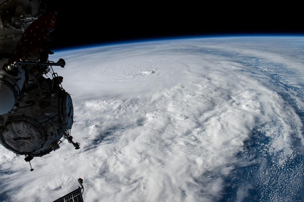
Hurricane Milton has swept through and battered central Florida, leaving several people dead, a widespread trail of property damage, and millions without power.
The system has now blown out into the Atlantic, some distance off the eastern coast of the United States. The system has weakened to maximum sustained winds of near 110 km/h. The US National Oceanic and Atmospheric Administration is forecasting additional weakening over the next several days.
Milton narrowly missed the Port of Tampa Bay (on the West Coast of Florida), which is now temporarily shut.
A statement from the port authority reads: “while the preliminary assessments of the port’s landside and seaside operations are underway, our port is currently without power. Some damage was observed to buildings but there has been no significant damage to docks, so far”.
Tampa is a multi-purpose port. It is known for handling fertilizer-related bulk commodities. Tampa Bay handles about 3.71m net tonnes of phosphate rock / chemical, according to the Port of Tampa Bay. Phosphate rock is a key ingredient in the production of fertiliser. According to the US Geological Survey, global phosphate production in 2023 was 63.6m tonnes. Tampa also handles about 18m tonnes of petroleum products, which appears to be destined for local consumption as ships transport most Floridian liquid energy imports to Tampa, and that liquid fuel is then transported by pipeline into central Florida to Orlando.
Like all ports, Tampa is the centre of a trade network. The trade that may be affected includes trade to and from South Louisiana, Veracruz (Mexico), Coatzacoalcos (Mx), Altamira (Mx), Houston, Lake Charles, Mobile, New Oreleans, Pasacagoula and Port Manatee, Progreso Yucatan (Mx), Canaveral Harbor (US), Tampa itself, Palm Beach (eastern Florida), Balboa (Panama), Port Arthur, Freeport (Bahamas) and Shanghai according to the IMF / Oxford University “Portwatch” initiative. There are also box shipping routes to Ningbo, Xiamen, and Yantian in China, along with cargo that is trans-shipped in Panama for various points in South America.
The port at Jacksonville (north eastern Florida) is also temporarily closed but plans to re-open Friday morning (local time); meanwhile, the Colonel’s Island Terminal (just over the state border in Georgia, about 88km north of Jacksonville) is not undertaking any vessel operations. Colonel’s Island is a major auto import terminal (the second busiest in the US for total ro/ro cargo and imports).
Shipping on routes to / from several major seaports on the southern US eastern coast are likely to be somewhat disrupted as ships are unlikely to sail through very stormy areas. Milton is occupying a sea area off the US coast stretching from the northern parts of the Bahamas to about about the mid-North Carolina coast. Windspeeds in that area are ranging from around 40 km/h to just under 100 km/h. Routes from Panama (the Canal), from Europe, to the US east coast ports Jacksonville, Savannah, and Charleston are likely to be disrupted for a few days until Milton blows out. Any vessels leaving those ports would likely either hug the coast and would likely wait to monitor the situation to see which direction the storm moves and / or if it weakens in intensity. Vessels sailing north from South America, Panama, or the Caribbean are likely to slowdown somewhat while the situation resolves. Vessels en-route to the southern parts US East Coast will also likely slowdown to monitor the situation and especially the track of the storm.
There are likely therefore to be some disruption and delays to vessels sailing to / from the ports in the southeast of the US East Coast for the next few days.
Milton “rapidly” and repeatedly intensified from a tropical depression over the Gulf of Mexico into a Category 5 storm earlier this week, with the US National Oceanic and Atmospheric Administration commenting that the storm “in strength and intensity at near record pace becoming one of the most intense hurricanes on record in the Atlantic basin”. According to NASA, rapid intensification occurs due to “very high ocean temperatures across the Gulf of Mexico that act as ‘fuel’ for hurricanes”.
NASA adds that the “The Atlantic hurricane season spans from June 1 to November 30 every year”.
According to an overview of the current science by the US Geophysical Fluid Dynamics Laboratory at Princeton University, and which is funded by US National Oceanic and Atmospheric Administration, has concluded that: “a future increase in tropical cyclone precipitation rates is likely; an increase in tropical cyclone intensity is likely; an increase in very intense (category 4 and 5) tropical cyclones is more likely than not; and there is medium confidence in a decrease in the frequency of weaker tropical cyclones”.
In simpler terms: there will likely be fewer but more intense cyclones with more rainfall.